
Chasing funnel clouds through the rolling hills of Rusk County to being pummeled with hail on the interstate in Harrison County, the KLTV Mobile StormTracker vehicle has already been put through the gauntlet. Wanting to test some modifications to the camera system on the chase vehicle, Meteorologist Grant Dade and I set out to track storms in West Texas.
Our journey began Thursday, May 23 with live reports on Good Morning East Texas as we drove toward Wichita Falls. Grant and I explained to viewers that the conditions were ripe for development to our west later that afternoon.
After several hours behind the wheel, we came to a stop in an area known as the Caprock, separating the high plains of the Texas panhandle. Watching radar in the vehicle, Grant let me know the chase was on. At more than two-thousand feet in elevation, we found a lookout northeast of Lubbock that was the perfect perch for watching the skies. Almost immediately, a thunderstorm caught Grant’s attention. Winds were whipping as we set up video and still cameras in the vehicle to capture bolts of lightning, flashing in the distance.

I was changing out a telephoto lens on my camera when Grant, like an excited child on Christmas morning, pointed to the horizon. A weak twister was spinning up in a remote area near the town of Floydada. Just as quickly as the rotation was clearly defined, it was gone. Dozens of camera shutter snaps later, we followed the same storm to Dickens County, with a convoy of fellow chasers in tow. Vehicles outfitted with cameras and weather measurement tools raced up and down farm roads, while vans packed with extreme weather tourists huddled along the side of the road.
Using the Davis weather station built into the StormTracker, we watched the wind speed ramping-up and the temperature dropping more than ten degrees. As the front passed through Dickens County, Grant pointed out this could be a long chase. An incredible amount of dust from the newly planted farmland was suspended in the air, making it difficult to see beyond a few hundred feet. Trying to intercept the storm a second time, our route down a farm road and directly into the path of a gustnado — a low-level rotating cloud that can form in a severe thunderstorm. The low visibility was unlike anything I had ever experienced. Swirling dust and sand made it impossible to see beyond the hood of the truck. We punched through the gustnado and kept driving toward the town of Jayton.
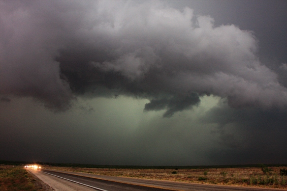
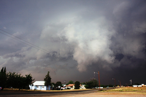
Ominous clouds created a nighttime feeling to the late afternoon sky, as the line moved in. Grant and I set up cameras on tripods in a parking lot just before the city’s “Welcome” sign. In the distance, two workers were scrambling down a communications tower, which, at the time seemed like the most dangerous place imaginable. Thankfully, they made it to safety just before the first flash of lightning.
Nearby, the Kent County Sheriff joined us roadside, watching a low cloud base and the sunlight’s greenish hue, peaking from behind. Not all the excitement was in the sky, my phone camera was rolling on an apparent dust-up involving the Discovery Channel’s “Storm Chasers” at a gas station in Aspermont. Their “Dominator,” a specially-outfitted armored chase vehicle, pulled up at the pump next to us.

A few moments later, they exchanged words with another chaser from across the parking lot. Somehow, one of the men winded up in a headlock next to our vehicle as they wrestled around. Our camera was rolling, their camera was rolling, and I started to question whether this was a legitimate exchange, considering how anti-climatic it was. Part of me questioned if this parking lot dust-up was staged for the cameras. The two went their separate ways and we pulled out as well.
Back on the road near Rotan, we measured 117 mile per hour winds, blistering the rolling plains. On his laptop, Grant was monitoring variables fed by National Weather Service Level 3 radar. Plotting a path through farmland, we followed the storm, which was weakening quickly. Storms were fizzling as the sun revealed an amazing sight near Sweetwater, pillowy mammatus clouds. Roadside, we snapped dozens of shots of the fading sunlight illuminating the clouds.
The next day, our journey home was uneventful until passing through Corsicana. Grant noticed a thunderhead building in the distance and again our camera were hoisted atop our tripods. The growing storms, which were at least 70 miles away, provided a great opportunity to experiment with a time-lapse sequence. More than a hundred shutters later, we were back on the road to Tyler.
Our West Texas trek gave me a glimpse at weather extremes: watching thunderstorms develop, identifying impressive cloud formations, and even my first tornado. The Mobile StormTracker vehicle served its purpose, allowing the opportunity to observe Mother Nature from a safe distance.
The views expressed in this blog do not necessarily reflect the views of KLTV/KTRE-TV or Raycom Media. They are solely the opinion of the author. All content © Copyright 2013 Lane Luckie

